
Map of Babylon

Map of Babylon 


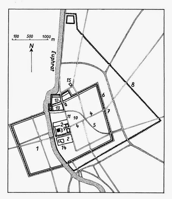
‎The map shows Babylon towards the end of the 7th and the beginning of the 6th millennium BCE.
‎1: New Town
‎2: Temple area Esagila
‎3: Ziggurat/Temple Tower Etemenanki (“House between Heaven and Earth”)
‎4: Marduk Way
‎5: Libilchegalla Channel
‎6: outer wall of the Walls of Babylon
‎7: Marduk Gate
‎8: City wall of Nebuchadnezzar
‎9: Holy Gate
‎10: Ishtar Temple
‎11: Processional Way
‎12: Ishtar Gate
‎13: Hanging Gardens
‎14: Marduk Temple
‎15: House of the New Year Festival
Gen 11:9; 2 Kings 17:24; 2 Kings 24:1, 2 Kings 24:7, 2 Kings 24:10; Ezra 4:9Ezra 5:13Ezra 5:17Ezra 6:1Ezra 6:5; Ps 137:1; Isa 13:19;  Isa 14:4;  Isa 21:9; Jer 29:15; Jer. 46:2; Jer. 50:1; Dan 2:48; Micah 4:10; Zech 6:10; Baruch 1:1, Baruch 1:4


Comments

Popular posts from this blog

Furnishings of the Tabernacle

Furnishings of the Tabernacle . ‎The book of Exodus details the construction of the tabernacle and its furnishings. As Yahweh’s sanctuary, the tabernacle served as God’s dwelling place among the Israelites—the expression of the covenant between Yahweh and His people ( Exod 25:8–9 ).

The Ten Plagues of Egypt

The Ten Plagues of Egypt

A Threshing Floor

A Threshing Floor In the ancient world, farmers used threshing floors to separate grain from its inedible husk (chaff) by beating it with a flail or walking animals on it—sometimes while towing a threshing sledge. Sledges were fitted with flint teeth to dehusk the grain more quickly. Other workers would turn the grain over so that it would be evenly threshed by the sledge.